
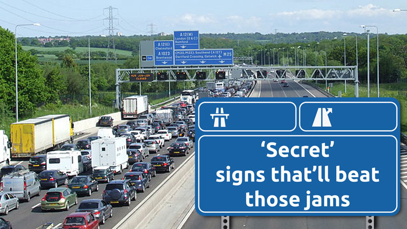
Stuck in traffic on a jam-packed motorway? Find out how thousands of “secret” signs are waiting to guide you through the gridlock on UK roads. These often-overlooked symbols could be your key to avoiding long queues and even bypassing motorway closures. Many drivers aren’t aware of them – a 2024 study found that diversion route symbols (those black squares, diamonds, triangles, and circles on yellow backgrounds) are not widely understood by road users, but with a little know-how, you can use them to save time and stress on your journeys. Let’s explain what these signs are, how they work, and how to use them to avoid motorway closures and congestion.

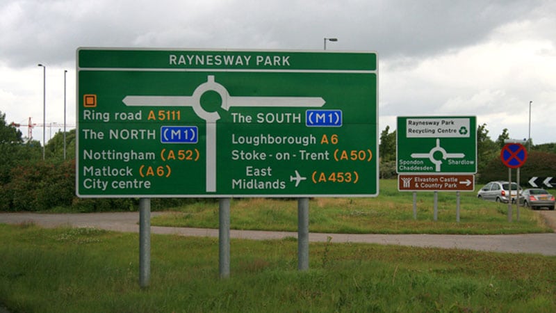
An example of an emergency diversion route symbol (black square on yellow) on a roadside direction sign. These “secret” motorway diversion signs in the UK help drivers navigate around closures or heavy traffic.
What Are Emergency Diversion Route Symbols?
Ever seen those odd black shapes on yellow patches attached to road signs? (Hint: check the image above, there’s a black square symbol if you look closely.) Despite wild myths that they’re secret codes directing VIPs to nuclear bunkers, they’re actually emergency diversion route symbols, official markers for pre-planned diversion routes on motorways. In other words, they’re “motorway diversion” signs used across the UK to guide all drivers along alternative roads if the main route is closed or congested.
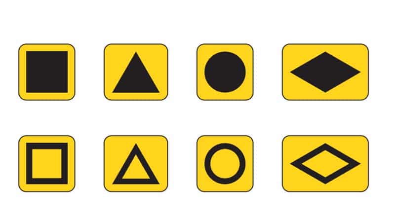
Each symbol is a simple geometric shape, commonly a square, triangle, circle, or diamond, always in black on a yellow background. They might be solid (filled in) or just an outline, which doubles the options to a total of eight distinct symbols. The shapes themselves don’t have specific meanings like “square means north” or “triangle means south.” Instead, they’re just different markers so that multiple diversion routes can operate in the same area without confusing drivers. For example, one junction’s detour might use a solid triangle while the next uses a hollow square, ensuring you follow the correct one for your route.
Filled vs. Hollow Symbols: You might notice some symbols are filled in (solid black shape) and others are hollow (black outline only). Generally, a filled shape indicates the primary diversion route, the main detour suitable for most traffic, while an outlined (hollow) shape is a secondary route, possibly a more local or narrower option. For instance, if heavy lorries need an alternate path due to a low bridge on the main diversion, authorities might designate a secondary route using the hollow version of the symbol for smaller vehicles. The key takeaway: if you leave one motorway junction following a triangle symbol, keep following that same triangle on each subsequent sign, don’t switch to a square or circle, and you’ll stay on the correct route.
In short, emergency diversion symbols are your pre-built escape routes for when motorways turn into parking lots. Now, let’s see how they actually work in practice.
How Do Emergency Diversion Routes Work?
Think of these symbols as part of a backup navigation system that National Highways (formerly Highways England) and local authorities have set up for drivers. Here’s what happens when there’s a serious incident and a motorway needs to be closed in an emergency:
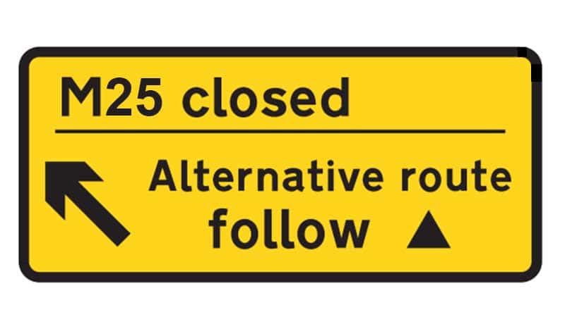
- Trigger Signs at the Motorway Exit: Traffic officers or police will close the affected motorway section, and everyone must leave at the previous junction. At that exit, they will unfold a bright yellow “trigger” sign (usually kept hidden when not in use) that tells drivers which symbol to follow. For example, the sign might say “M25 closed, follow”, indicating you should follow the route marked by a triangle symbol to get around the closure. (This sign often includes an arrow showing the direction of the detour, arrows simply point you where to go, e.g. an upward arrow might mean the diversion goes over or across an obstacle ahead, while a downward arrow could suggest going under/around one. In any case, just follow the arrow’s direction along with the symbol.)
- Following the Symbol on Local Roads: Once off the motorway, just follow the indicated symbol. The emergency diversion route is permanently signposted on local roads using those black-on-yellow symbols, placed on existing direction signs or on standalone yellow signs. Every time you reach a junction or turn, look for a sign with the same symbol (e.g. a black triangle) and go wherever that sign directs. The symbols will lead you through a carefully chosen route of A-roads or suitable main roads that can handle all the diverted traffic. These routes avoid low bridges, weight limits, or tight spots, so all vehicles, from cars to HGVs, can safely use them.
- Rejoin the Motorway Past the Closure: The diversion will eventually bring you to the next accessible motorway junction beyond the incident, where you can merge back onto the motorway. Often, there’s another folding sign at that re-entry point confirming you’re returning to the motorway, or directing you to continue following the symbol to an even further junction if the closure spans multiple junctions. In this way, several diversion routes can daisy-chain together if needed, leapfrogging you around a long stretch of closed motorway.
That’s it, no maps or guesswork needed at the time of the incident. The system is designed so that as soon as the trigger sign is activated, the diversion route is ready to use (since all the symbol signs are permanently in place and just waiting for you to notice them).
It’s a bit like a hidden detour waiting in the wings for its moment to shine. And indeed, most of the time you won’t even realise these symbols are all around, because when the motorway network is running normally, they quietly blend into the background.
Where Can I Find These “Secret” Signs?
Short answer: pretty much anywhere there’s a major junction on a motorway or trunk road. If you’re near a motorway, especially close to a junction, keep an eye on the regular direction signs, you’ll often spot a small yellow patch with a symbol on it (solid or hollow square, triangle, etc.). They might look odd when you’re not actively using them, but they’re placed there strategically so that whenever a diversion is activated, the signs are already in position to guide you.
On the motorway itself, you typically won’t see much until something happens. The critical signs on the motorway are those trigger signs mentioned earlier, usually covered or folded away. They’re located near or at each exit (slip road) and will only be visible when there’s an active diversion. If you ever pass a motorway exit and notice a bright yellow sign has been unfolded telling you to follow a symbol, you know the motorway ahead is closed and you should probably take that exit!
Meanwhile, on the side roads and A-roads around the motorway, the symbols are always visible. They’re usually mounted on existing road signs. For example, at a roundabout near a junction, you might see arrows pointing to towns along with a black circle or square indicating “this way for the official diversion route.”
Important: When the motorway is open and you’re just driving normally, there won’t be any flashing lights or instructions on electronic boards about these symbols. They’re just there. So, unless you’re intentionally looking to use a diversion route, you might ignore them (as most people do). But if you know what to look for, you can take advantage of them even during normal conditions, which brings us to…
Can I Use Diversion Signs to Avoid Traffic Jams (Even If the Motorway Isn’t Closed)?
Yes! This is a clever hack that not everyone realises: you don’t have to wait for an official closure to use these pre-planned routes. If the motorway ahead is badly congested (accident, holiday traffic, who knows) and you’re crawling along, you can choose to “junction-hop” using the diversion routes:
- Exit the Motorway Early: Leave at the upcoming junction before the gridlock. As you come off the slip road, look out for the first road sign with one of those diversion symbols.
- Follow the Symbol Signs: Turn onto the road indicated, and from there, keep following that same symbol on each subsequent sign. The symbols will guide you along a route that has been selected to handle traffic flow efficiently, often an official diversion route to the next major junction. If the next junction is still jammed, you could even continue onto the next symbol (some areas have routes daisy-chained beyond one junction).
- Rejoin Further Downstream: The route will lead you to a re-entry point beyond the worst of the traffic. With luck, you’ll merge back onto a freer-moving section of motorway, effectively skipping the queue of cars stuck behind the original incident or bottleneck.
This can be a real time-saver and a stress reliever. Instead of sitting in stop-start traffic for an hour, you might take a 15-minute scenic detour and be on your way. These official “secret” back routes often avoid known pinch-points like busy town centres or narrow lanes, so they’re typically faster than any random back road your sat-nav might suggest.
However, a couple of important caveats when using diversion symbols proactively:
- Know the Right Symbol: If there’s only one diversion route in the area, this is straightforward; just follow whichever symbol you see. But around major intersections, there could be multiple different symbols for different directions or destinations (for example, one diversion might head to another motorway, while a second symbol leads to a different town). In those cases, you’ll need to pick the correct one; otherwise, you might end up looping somewhere you didn’t intend. If you’re unsure, it may require a quick check (more on how to figure out the correct symbol in the next section).
- Trust the System (Within Reason): Remember that these routes are designed to handle all motorway traffic in an emergency, so they usually stick to decent roads. Don’t be tempted to stray from the symbol route, thinking you know a “shortcut”, chances are the official route is the safest bet to avoid weight limits, height restrictions, or dead-ends. Still, be mindful of real-time conditions: if you hit unexpected roadworks or an accident on the diversion route (hey, it happens), use common sense and re-evaluate your plan.
- Obey Normal Traffic Rules: Even though you might feel like you’re on a special secret mission following triangles and squares, normal speed limits, signals, and road rules all still apply! Always drive safely and adapt to road conditions.
In summary, yes, you can absolutely use these motorway diversion signs to avoid heavy congestion; it’s one of the reasons they’re such a handy tool for savvy drivers. Just do a tiny bit of homework if possible, and you’ll be cruising past the gridlock in no time (while everyone else wonders how on earth you knew to go that way!).
How Do I Find Out Which Symbol to Follow for My Route?
If the motorway is closed and you’re being diverted, the guesswork is minimal; the big yellow trigger sign at the closure will tell you which symbol to follow (e.g. “Follow the symbol”). But if you’re planning ahead to dodge traffic, or if you suspect multiple diversions around your area, it helps to know the right symbol in advance. Here’s how to figure it out:
- Check Traffic Reports & Media: When a major incident closes a motorway, National Highways and the local authorities usually spread the word through traffic news. Listen to radio traffic bulletins or use live traffic apps; they often mention something like, “M6 closed northbound between J14 and J15, follow the solid square diversion route”. Overhead electronic signs on the motorway might also display messages with a symbol. Being aware of these alerts can clue you in on the correct route symbol before you even get there.
- Google It: A quick web search can do wonders. Simply type a query like “Emergency diversion route symbol M25 junction 9”. Replace with your motorway and junction of interest. Often, results will include news updates, forum discussions, or even official info from past incidents that reveal which symbol was used for that stretch. Because these routes are permanent, the symbol for a given diversion doesn’t usually change, so even if the info is from a previous incident, it’s likely still valid.
- Twitter (X) & Social Media: Twitter can be a goldmine for real-time info. Try searching for hashtags or keywords like “#M25 diversion symbol” or “M25 J9 diversion”. People stuck in past jams or local police and travel news accounts often tweet details during incidents. For example, users might have posted “Accident on M25, all traffic being sent off at J9, follow the hollow circle symbol.” By digging up those tweets, you get insight into the official route. (Remember, Twitter has been rebranded as X, but you can still use the same search strategies there or on other platforms.)
- Official Resources: National Highways’ website and some regional traffic agencies provide diversion information for major planned closures. In some regions, there are online maps of diversion routes or lists for major roadworks. It’s worth checking the official site if you have advance notice of a closure. That said, a comprehensive public list of all emergency diversion routes doesn’t exist (a past Freedom of Information request for it was even refused due to the effort/cost required), so you may not find a simple database of “junction X = triangle, junction Y = square.” Your best bet is still searching incident by incident.
A crucial safety note: Do any searching before you set off, or have a passenger do it. If you’re already on the road and things are snarled up, resist the temptation to grab your phone to look up symbols; using a mobile while driving is illegal and dangerous. Also, do not stop on the hard shoulder just to fiddle with your phone or map; the hard shoulder is for true emergencies only. It’s better to take the exit (you’re about to anyway) and pull over in a safe place off the carriageway if you must check something. But ideally, plan ahead.
The good news is that these routes are usually intuitive once you’re on them. They’re designed to be as free-flowing as possible and avoid major pinch-points, so you can often just follow the steady trail of black symbols and trust that it’s taking you the right way. Keep an eye out for those yellow signs, and you’ll navigate through unfamiliar roads like a pro.
Example of a road sign showing a hollow diamond diversion symbol. This indicates the official diversion route to rejoin the motorway, in this case, guiding drivers around an incident on the M1. Just follow the black symbol on a yellow background until you’re back on track!
Isn’t This What My Sat-Nav Is For?
You might be thinking, “If there’s a closure or jam, won’t Google Maps or my car’s navigation just reroute me anyway?” It’s true that modern sat-navs and apps are pretty smart, they do try to find you a quicker route if traffic builds up. However, sat-navs don’t always know best when it comes to major diversions.
The difference is local knowledge and planning. Emergency diversion routes are carefully chosen by local highway planners, sometimes years in advance. They consider factors that sat-nav algorithms might overlook, such as: avoiding small villages or town centres that can’t handle heavy traffic, staying clear of roads with height/weight restrictions (vital for trucks and buses), and minimising turns or confusion points for a smoother flow. Essentially, these routes are the optimum detours for a worst-case scenario, vetted by experts who know the area.
Your sat-nav, on the other hand, might pick a route that appears faster on traffic data but could send you down narrow country lanes or into busy urban streets not suitable for all vehicles. It’s using general algorithms without the benefit of that human planning. In some cases, the sat-nav’s choice could be a “blunter tool”, maybe fine for a lone car, but not ideal when you’re a line of hundreds of vehicles being diverted.
That said, there’s no harm in comparing. If your navigation app suggests a similar route to the official diversion, great, you’ll get the added guidance of turn-by-turn voice directions along the same path (since the app won’t specifically say “follow the triangle,” it’ll just say road names). In many situations, though, you’ll find that the recommended sat-nav route differs from the signed diversion. When in doubt, especially if you’re unfamiliar with the area, you might want to stick with the emergency diversion signs, they’ve literally been put there to help all drivers, including out-of-towners, avoid getting lost.
Interestingly, even the authorities recognise this: Transport Focus (the road users’ watchdog) found that a lot of drivers don’t fully trust the official diversions and often prefer their sat-nav or own instincts. But that’s something they’re trying to improve, because in many cases the official route is the safer bet. In fact, efforts are ongoing to provide sat-nav companies with better data on these diversions so the apps can align with them. Until then, consider the pros and cons, but know that those “secret” diversion signs are a tried-and-true option when things go wrong on the motorway.
Are These Diversion Routes Publicly Available or Listed Anywhere?
One common question is whether you can get a map or list of all the emergency diversion routes (sometimes called “tactical diversion routes”) for planning purposes. The idea is appealing – imagine knowing ahead of time every back road you’d take if any given junction on your route shut down. Unfortunately, there isn’t a publicly accessible master list or map of all diversion routes.
National Highways has these routes planned and documented internally, but as mentioned earlier, a request to release them all was denied because compiling it would have been very costly. There are simply so many possible diversions across the country that it’s not practical to publish and maintain a full database for drivers.
However, you can piece together knowledge for specific areas with a bit of research. Some local highway authorities publish diagrams of diversions for major planned works. Enthusiast websites and forums sometimes discuss known diversion symbols for particularly notorious spots. And if you often travel the same motorways, over time, you might note the symbols on signs around each junction, which alone can help you guess which symbol leads where.
Also, as diversions become more talked-about, resources may improve. (The Transport Focus study in 2024 called for better communication and signage so drivers aren’t left in doubt on diversions.) In the future, we might see greater awareness and possibly tools to help with diversion routes. For now, though, it’s a bit of a scavenger hunt, which is why knowing how to quickly search on the fly is useful.
And remember: even if you had a list, always pay attention to the actual signs on the day. Road conditions or incidents can sometimes make authorities choose a different route than the usual one. Trust what the roadside signs are telling you at that moment, because that will be the most up-to-date guidance.
Quick Tips for Using Motorway Diversion Signs
- Stay Alert at Junctions: When approaching a junction (especially during heavy traffic or if you’ve heard of problems ahead), glance at roadside direction signs for any yellow symbol patches. They’re small but hard to miss once you know to look, and they’ll hint at available diversion routes.
- Consistency is Key: If you decide to follow a diversion symbol (whether instructed by officials or by choice), stick to it all the way. Don’t swap symbols mid-route. If you see a different shape appear, that likely means another diversion intersects or runs nearby, ignore it and keep following your original one.
- Don’t Speed on Unknown Roads: Diversion routes aim to be efficient, but they’re still unfamiliar roads for most drivers. They might pass through rural areas or have sharp bends. Give yourself time by not rushing; it defeats the purpose if you have an incident on the diversion!
- Be Patient if Everyone’s Diverting: In a major closure, everyone is following those signs, so you won’t be alone on the back roads. Some congestion can still occur on the diversion route (e.g. at traffic lights or roundabouts). Don’t panic, it’s usually far better than the standstill you left, and traffic officers may assist at critical points if needed.
- Know When to Call It Quits: If you miss a symbol or feel like you’ve lost the route, you can often safely pull over at a petrol station or lay-by to get your bearings (or use navigation to regain the route at the next junction). It’s better to stop and figure it out than to aimlessly wander. The good news is the symbols are frequent enough that if you haven’t seen one in a while, that’s your cue to double-check.
By keeping these tips in mind, you’ll join the ranks of the travel-savvy who can confidently say: “Motorway closed? No problem, I know another way!”
Check Your Car’s MOT, Tax & Insurance Status: Before you hit the road (especially on a long trip where unexpected diversions might occur), make sure your vehicle is fully legal and ready. It’s quick and easy to verify that your car’s MOT, road tax, and insurance are all up to date, you can click here to check your details online. Don’t get caught out by an expired document when you need your car the most!
Frequently Asked Questions (FAQs)
They are emergency diversion route symbols, basically motorway diversion signs used in the UK. They come in four basic shapes (triangle, square, circle, diamond), shown in black on a yellow background. These symbols are placed on existing road signs and indicate pre-planned detour routes to follow when the usual road (like a motorway) is closed or congested. They are not secret messages or random logos, but part of an official system to guide drivers along alternative roads.
When a motorway is closed, there will be prominent yellow “trigger” signs at the point of closure or the exit you’re directed to. That sign will display a specific symbol and sometimes an arrow, telling you something like “Follow the (triangle)” or “Follow the (square) symbol”. Simply leave at that junction and adhere to that symbol on all subsequent signs; it will lead you around the closure and back to your route. You can also check travel news: radio reports, highway message boards, or Twitter updates from National Highways often mention which symbol to follow for a given incident. Prior knowledge helps, but the on-the-day signage is your best guide.
Yes, absolutely! If you know or suspect that traffic ahead is badly jammed (even if not fully closed), you can proactively take the next exit and follow the diversion symbols to skip ahead. The symbols are always there on the local roads, even during normal conditions. However, if there are multiple different symbols in that area (for different routes), you might need to find out which one leads to your desired destination (like the next motorway junction), and a quick online search or prior experience helps. Using diversion routes in this way is a bit of a local life-hack to avoid motorway queues. Just remember that if the motorway isn’t closed, there won’t be an official sign telling you which symbol to use, so you’ll be relying on your own knowledge or prep.
Not necessarily. Your sat-nav (or Google Maps, Waze, etc.) will usually detect heavy traffic or closures and try to reroute you, but it might not choose the exact pre-planned diversion route that the highway authorities have set. In some cases, it could send you on a smaller road that it thinks is faster, whereas the official route might be slightly longer in distance but more suitable for all traffic (e.g., avoiding narrow lanes or weight limits). The sat-nav doesn’t understand the diversion symbols at all, it’s just calculating based on maps and traffic. Sometimes it may coincidentally pick the same route, especially if that is genuinely the quickest option. Other times, you might see it suggest a different path; use judgment here. If the official signs are clear and you’re unsure about the sat-nav’s alternative, following the emergency diversion signs is a safe bet, especially for larger vehicles. Remember, those routes were designed with local expertise. You can always re-enable your navigation after you’ve followed the symbols off the motorway to help guide you turn-by-turn along the known diversion route.
. In many cases, they will be faster (or at least, they’ll get you moving instead of stuck in a standstill). They’re intended to keep traffic flowing when the motorway can’t. However, there’s no absolute guarantee. Occasionally, if the closure is short or gets cleared quickly, or if everyone dives onto the diversion at once, you might find that sticking it out on the motorway (or rejoining it as soon as possible) ends up being just as quick. Also, rare unforeseen issues (like accidents on the diversion route, temporary roadworks, etc.) can slow those routes. The general rule: if the motorway ahead is closed or barely moving, the diversion route is usually your best option. But use common sense, listen to traffic updates and observe the situation. And always follow official instructions from police or traffic officers on the scene. The aim is to get you around the problem safely, not to win a race. So while diversion routes are there to help, they aren’t a magic teleport; consider them a well-planned alternate road that, in most scenarios, will save you time, but not an absolute certainty in every single case.
Disclaimer: The information in this article is up-to-date as of September 2025 and is intended to help drivers understand and use the emergency diversion route system. Always follow official road signs, electronic displays, and instructions from authorities when driving. While diversion symbols can guide you around closures or congestion, there is no guaranteed outcome; road conditions can change quickly. Use these routes at your own discretion and stay alert. Safe driving!